Slope Stability Monitoring for Highways and Railways: An Engineer's Field Guide
Maintaining the stability of slopes along highways and railway lines is critical for ensuring safety and preventing costly disruptions. Landslides and slope failures can result in significant economic losses, environmental damage, and, most importantly, endanger lives. This guide provides civil engineers and geotechnical professionals with a practical understanding of modern slope stability monitoring systems, focusing on effective implementation and data interpretation in the Indian context.
Who This Guide Is For
- Civil Engineers: Involved in the design, construction, and maintenance of highways and railways.
- Geotechnical Consultants: Providing expertise in soil mechanics, slope stability analysis, and instrumentation.
- Infrastructure Project Managers: Overseeing the execution of highway and railway projects, responsible for risk management.
- Procurement Leads: At NHAI, RVNL, CPWD, and smart city bodies, tasked with selecting and implementing monitoring solutions.
Understanding Slope Instability and Its Impact
Slope instability can arise from various factors, including rainfall infiltration, seismic activity, erosion, and changes in groundwater levels. In India, regions like the Himalayas, Western Ghats, and Northeast are particularly susceptible to landslides. Early detection of slope movement is crucial for implementing timely mitigation measures, such as retaining walls, drainage improvements, and slope stabilization techniques.
Ignoring early warning signs can lead to catastrophic failures, resulting in:
- Road and railway closures
- Damage to infrastructure
- Loss of life
- Significant financial burdens for repair and reconstruction
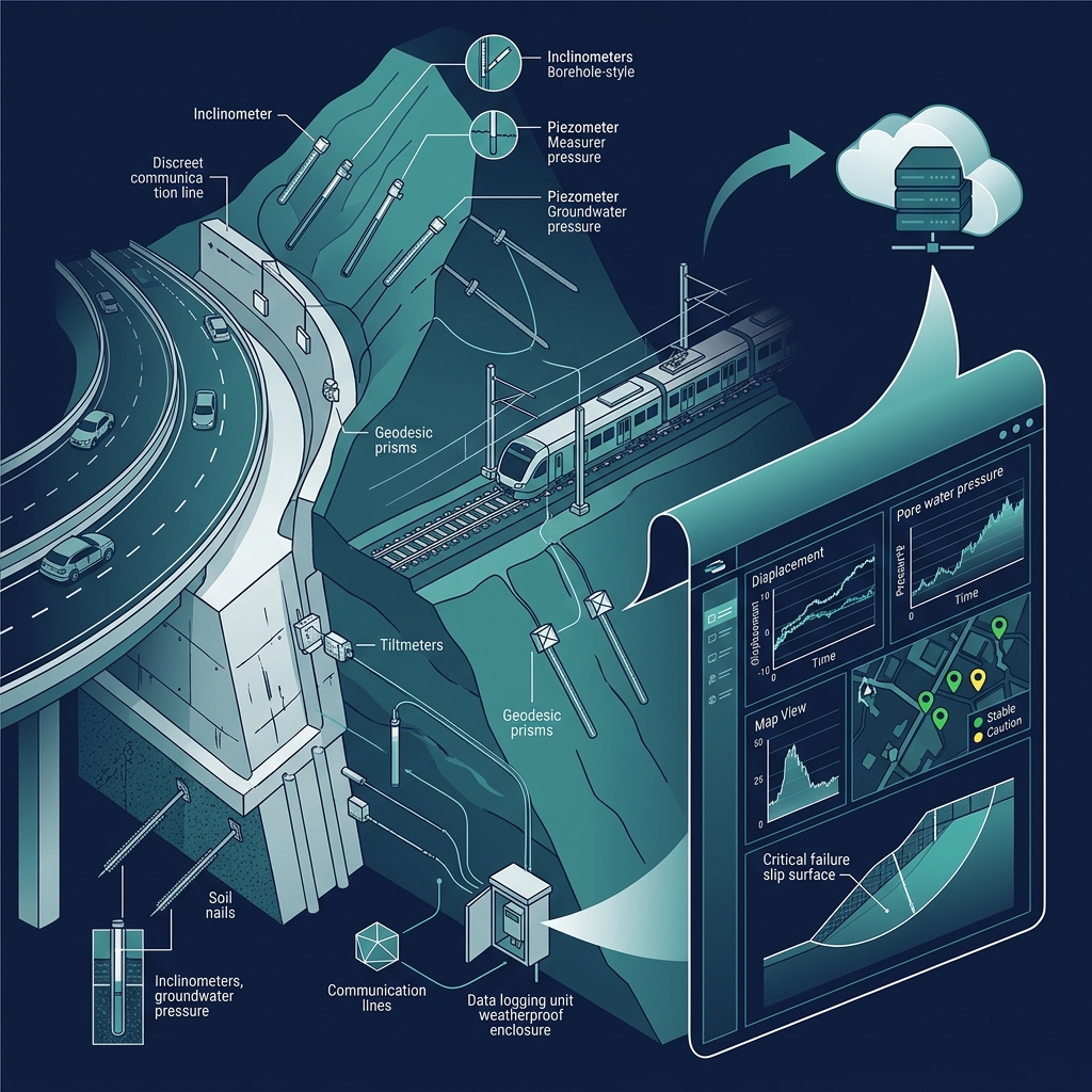
Key Components of a Slope Stability Monitoring System
A comprehensive slope stability monitoring system typically integrates various sensors and data acquisition systems to provide real-time insights into slope behavior. The most common components include:
- Inclinometers: Measure subsurface ground movement and deformation.
- Piezometers: Monitor pore water pressure within the soil mass.
- Rainfall Gauges: Track rainfall intensity and cumulative rainfall, a critical trigger for landslides.
- Extensometers: Measure surface cracks and displacement.
- Data Loggers and Telemetry: Collect and transmit data from sensors to a central monitoring platform.
Inclinometers and Piezometers: A Powerful Combination
The combination of inclinometers and piezometers provides a robust understanding of slope behavior. Inclinometers detect the magnitude and direction of subsurface movement, while piezometers measure changes in pore water pressure, which can significantly influence slope stability.
By analyzing data from both instruments, engineers can identify potential failure surfaces and assess the risk of landslides. For instance, an increase in pore water pressure coupled with increasing inclinometer readings may indicate an imminent slope failure.
Rainfall-Triggered Alerts for Proactive Response
Rainfall is a major trigger for landslides, especially in regions with heavy monsoon seasons. Integrating rainfall gauges into the slope stability monitoring system allows for the establishment of rainfall thresholds that trigger alerts when exceeded.
These alerts can be configured to notify relevant personnel via SMS or email, enabling them to take proactive measures, such as temporarily closing roads or railways, evacuating vulnerable areas, and deploying emergency response teams. Setting appropriate thresholds requires careful consideration of local rainfall patterns and historical landslide data.
Real-World Examples in Indian Landslide-Prone Corridors
Several successful implementations of slope stability monitoring systems exist in India's landslide-prone corridors. For example:
- Konkan Railway: Implemented a comprehensive monitoring system along its route to mitigate the risk of landslides during the monsoon season.
- National Highway 58 (Rishikesh-Badrinath): Utilizes real-time monitoring to ensure the safety of pilgrims and commuters.
- Various Hill Roads in Himachal Pradesh and Uttarakhand: Employ slope monitoring to prevent disruptions and ensure connectivity.
These examples demonstrate the effectiveness of proactive monitoring in reducing the impact of landslides and ensuring the safety of infrastructure and people.
Geolook vs Traditional Approach
Traditional slope monitoring methods often rely on manual inspections and infrequent data collection, which can be time-consuming and prone to errors. Geolook offers a real-time, automated solution that provides continuous data and alerts, enabling faster response times and more informed decision-making. Our clients have reported up to 30% reduction in landslide-related disruptions and a 15% decrease in maintenance costs by switching to Geolook's SHM platform.
Comparison Table
| Feature | Geolook | Encardio-Rite |
|---|---|---|
| Data Acquisition | Real-time, continuous | Periodic, manual/automatic |
| Alert System | Customizable, SMS/Email | Basic threshold alerts |
| Data Visualization | Interactive dashboards, GIS integration | Standard graphs and reports |
| Indian Project Suitability | Specifically tailored for Indian conditions and regulations | General solutions, may require customization |
| Maintenance | Remote diagnostics, minimal on-site maintenance | Requires regular on-site maintenance |
| Scalability | Easily scalable to accommodate large projects | Scalability may be limited |
Download: Slope Monitoring Deployment Checklist
Ready to implement a slope stability monitoring system? Download our comprehensive Slope Monitoring Deployment Checklist to ensure a smooth and effective implementation process. Download the Checklist Now.
Frequently Asked Questions
Q: What is the typical lifespan of inclinometers and piezometers?
A: With proper installation and maintenance, these instruments can last for 10-15 years.
Q: How often should I calibrate the sensors?
A: Calibration frequency depends on the sensor type and environmental conditions, but typically every 1-2 years.
Q: Can I integrate Geolook with my existing monitoring systems?
A: Yes, Geolook offers flexible integration options to connect with various data sources and platforms.
Q: What level of training is required to operate the Geolook system?
A: We provide comprehensive training programs for operators and engineers to ensure effective system utilization.
Q: How does Geolook handle data security and privacy?
A: Geolook employs robust security measures to protect data integrity and confidentiality, complying with industry best practices.
Conclusion
Implementing a robust slope stability monitoring system is essential for mitigating the risks associated with landslides and ensuring the safety of highways and railways. By leveraging advanced technologies like inclinometers, piezometers, and rainfall-triggered alerts, engineers can proactively identify and address potential slope failures, minimizing disruptions and protecting lives. Geolook provides a comprehensive and reliable solution tailored to the specific needs of Indian infrastructure projects.
Ready to Enhance Your Slope Monitoring?
Contact Geolook today to discuss your specific slope stability monitoring needs and discover how our platform can help you improve safety, reduce costs, and ensure the long-term integrity of your infrastructure projects. Our team of experts is ready to provide tailored solutions and support to meet your unique challenges. Explore our blog for more insights, and check out our articles on IoT in civil engineering and dam monitoring systems.