Real-Time Slope Monitoring System for Landslide Prevention India
In August 2017, a series of landslides along NH-44 in the Ramban–Banihal corridor of Jammu & Kashmir blocked the highway for over 72 hours, stranding thousands of vehicles and severing the only all-weather road link between Jammu and Srinagar. The event was not anomalous — the Geological Survey of India (GSI) classifies more than 0.49 million sq km of Indian territory as landslide-prone, with the highest hazard zones concentrated along the Himalayas, Western Ghats, and North-East hill states. For highway authorities and State Disaster Management Authorities (SDMAs), the question is no longer whether a slope will move, but whether the movement will be detected early enough to act. A real time slope monitoring system for landslide prevention india addresses precisely that gap — converting continuous geotechnical data into actionable early warnings before a failure propagates to the road surface or populated area below.
Key Takeaways
- A real time slope monitoring system for landslide prevention india integrates MEMS inclinometers, piezometers, rain gauges, and IoT gateways to deliver sub-minute alert latency on critical slopes.
- IS 14458 (Parts 1–3) and NDMA's 2009 guidelines on landslide hazard zonation provide the regulatory baseline for instrumentation design and threshold setting in India.
- Landslide early warning thresholds are defined by combining displacement velocity (mm/day), pore-water pressure (kPa), and rainfall intensity (mm/hr) — no single parameter is sufficient alone.
- Slope IoT architectures must account for power and connectivity constraints in remote hill terrain; solar-powered edge nodes with 4G/satellite fallback are the practical standard.
- Hill sensors India deployments require corrosion-resistant housings rated to IP67 or better, given monsoon humidity and freeze-thaw cycles above 2,000 m elevation.
What Is a Real-Time Slope Monitoring System?
A real-time slope monitoring system is an integrated geotechnical instrumentation network that continuously measures slope deformation, pore-water pressure, and environmental triggers, transmits data over a wireless or cellular link, and generates automated alerts when pre-defined threshold conditions are exceeded — enabling highway operators or SDMAs to initiate traffic closures or evacuation before a slope failure occurs.
The distinction from periodic manual survey is fundamental. A total-station survey conducted fortnightly captures a snapshot; a real time slope monitoring system for landslide prevention india captures the acceleration phase of movement — the hours or days during which displacement velocity rises from background creep (typically <1 mm/day on stable slopes) toward the critical velocity range (often >10 mm/day) that precedes rapid failure. The NDMA guidelines on landslide hazard management (2009) explicitly recommend continuous monitoring for Category I and II hazard zones along national highways.
For a deeper treatment of instrumentation selection across slope hazard categories, see our guide on slope stability monitoring.
System Architecture: Sensors, Edge Nodes, and Cloud Analytics
A production-grade real time slope monitoring system for landslide prevention india is built in three functional layers: the sensing layer, the edge-communication layer, and the cloud analytics and alerting layer.
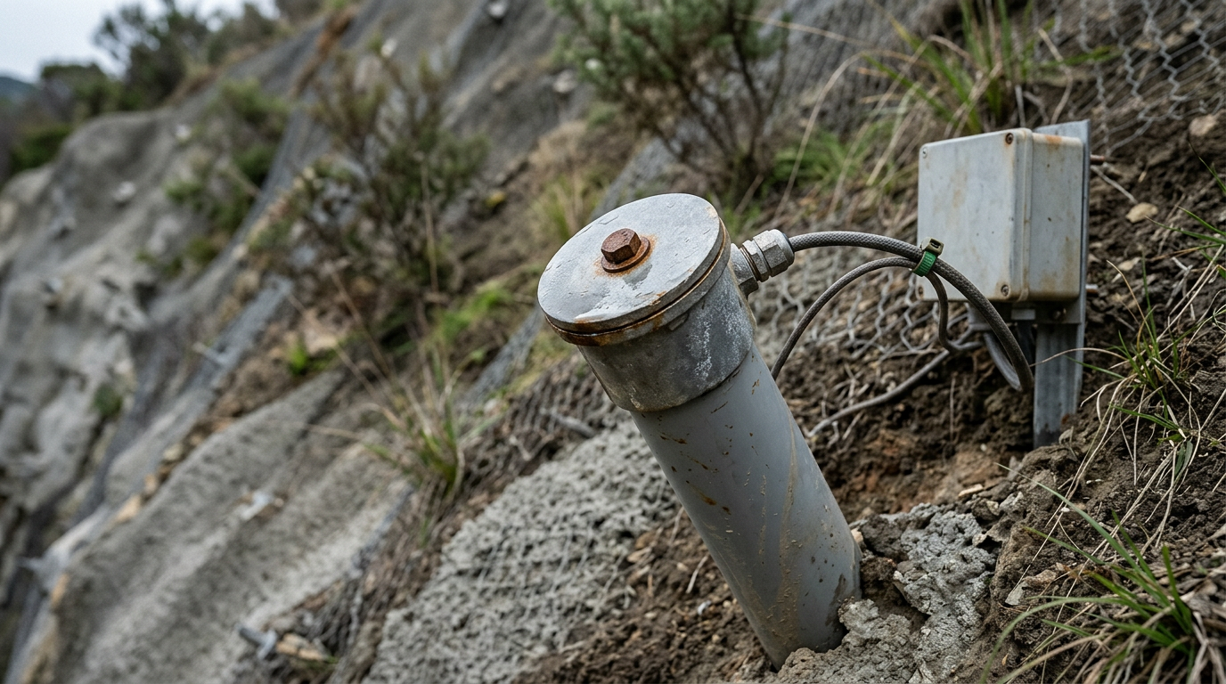
Sensing Layer. The primary deformation sensor on an instrumented slope is the in-place inclinometer or MEMS digital inclinometer, installed in a near-vertical borehole drilled through the active failure mass into stable bedrock. MEMS-based sensors measure tilt in two orthogonal axes with a resolution of ±0.001° and output angular displacement in micro-radians, which is converted to lateral displacement in millimetres using the gauge length between sensor nodes. A 30 m borehole fitted with sensors at 1 m intervals provides a continuous displacement profile, identifying the depth of the shear zone to within ±50 mm. Complementing the inclinometer array, vibrating-wire piezometers monitor pore-water pressure (range typically 0–350 kPa, resolution 0.025% FS) at the failure plane depth, since pore-pressure rise is the primary trigger mechanism for translational slides in colluvial soils classified under IS 1892. Tipping-bucket rain gauges (0.2 mm resolution) provide the rainfall intensity input required by intensity-duration-frequency (IDF) threshold models.
Edge-Communication Layer. In hill terrain across Himachal Pradesh, Uttarakhand, or the North-East, grid power and fibre connectivity are unreliable. Each sensor cluster connects to a solar-powered data acquisition unit (DAQ) with a minimum 72-hour battery backup. The DAQ samples sensors at configurable intervals — typically every 15 minutes for background conditions, switching to every 1 minute when a pre-alert threshold is crossed. Data is transmitted over 4G LTE with automatic fallback to satellite (VSAT or BSNL NMS) when cellular coverage drops. Edge processing at the DAQ level enables local alarm relay outputs (dry contact, 24 V DC) that can trigger physical barriers or variable message signs without cloud round-trip latency.
Cloud Analytics and Alerting Layer. Ingested data feeds a time-series database where threshold logic is applied across three alert levels: Advisory (displacement velocity >1 mm/day or pore pressure >60% of design limit), Warning (velocity >5 mm/day or pore pressure >80%), and Evacuation (velocity >10 mm/day or pore pressure >95%). Alerts are dispatched via SMS, email, and API push to SDMA control rooms. Dashboards display displacement vectors, piezometric surfaces, and rainfall accumulation on a GIS base map, enabling field engineers to correlate sensor data with slope geometry defined in IS 14458 Part 2.
To understand the full range of field instruments that feed this architecture, refer to our detailed overview of what instruments are used to detect early signs of slope instability and landslides.
Landslide Early Warning Thresholds: The Engineering Basis
Landslide early warning systems fail when thresholds are set arbitrarily rather than derived from site-specific geotechnical data. The correct approach, consistent with NDMA guidelines and IS 14458 Part 3, combines three independent trigger parameters into a multi-variate threshold model.
Displacement velocity. Background creep on a marginally stable slope in Himalayan colluvium typically ranges from 0.1 to 0.5 mm/day. The pre-failure acceleration phase, described by Fukuzono's inverse-velocity method, shows a characteristic increase in displacement rate that can be extrapolated to estimate time-to-failure. An Advisory threshold is commonly set at 1 mm/day; the Evacuation threshold at 10–15 mm/day, calibrated against historical failure records for the specific lithology.
Pore-water pressure. For a slope with a factor of safety (FoS) of 1.3 under drained conditions, a rise in pore-water pressure ratio (ru) from 0.1 to 0.3 can reduce FoS below 1.0 in low-plasticity silts. Piezometer readings are converted to ru values and compared against the stability envelope computed from IS 1892 soil parameters. A pore-pressure threshold of 80% of the critical ru triggers a Warning alert.
Rainfall intensity-duration. The GSI has published regional rainfall thresholds for landslide initiation across Indian hill zones. For the Uttarakhand Lesser Himalayas, a 24-hour rainfall exceeding 100 mm is a recognised trigger; for the Western Ghats, cumulative antecedent rainfall over 15 days is the more reliable predictor. The rain gauge data from the slope IoT network is compared against these published IDF curves in real time.
Explore the full instrumentation toolkit for threshold-based systems in our guide to best instruments for early landslide warning systems.
Sensor Selection for Indian Hill Terrain
Hill sensors India deployments face environmental stresses that differ substantially from plains infrastructure. Selecting the correct sensor specification is as important as the system architecture.
MEMS digital inclinometers are preferred over traditional servo-accelerometer inclinometers for permanent in-place installations because they have no moving parts, consume less than 5 mA at 3.3 V, and maintain calibration stability over temperature ranges of −20°C to +70°C — relevant for high-altitude sites in Ladakh or Sikkim. Geolook's MEMS digital inclinometer is designed for borehole installation in 70 mm nominal casing, compatible with IS 2720 Part 4 borehole preparation standards.
Vibrating-wire piezometers are specified with a stainless-steel diaphragm and hermetically sealed coil to resist the high humidity (RH >95%) common during the Indian monsoon. Thermistor-integrated models compensate for the temperature-induced frequency drift that can introduce errors of up to 2 kPa per 10°C change if uncorrected.
Surface displacement is cross-validated using GNSS settlement monuments (sub-centimetre accuracy with RTK correction) and crack meters (range 0–50 mm, resolution 0.01 mm) installed across tension cracks at the crown of the slide. This multi-sensor redundancy is essential: a single sensor failure in a remote hill location may not be detected for days, and redundancy prevents false negatives in the early warning chain.
Sensor Technology Comparison for Slope Monitoring Applications
The table below compares the primary sensor technologies used in a real time slope monitoring system for landslide prevention india, evaluated against parameters relevant to highway and SDMA procurement decisions.
| Sensor Type | Measured Parameter | Typical Range | Resolution | Power Consumption | Suitability for Remote Hill Sites |
|---|---|---|---|---|---|
| MEMS Digital Inclinometer (in-place) | Lateral displacement / tilt | ±30° | 0.001° | <5 mA at 3.3 V | High — no moving parts, wide temp range |
| Vibrating-Wire Piezometer | Pore-water pressure | 0–350 kPa | 0.025% FS | Passive (read on demand) | High — hermetic seal, monsoon-rated |
| Tipping-Bucket Rain Gauge | Rainfall intensity | 0–500 mm/hr | 0.2 mm/tip | <2 mA active | High — simple mechanical, low maintenance |
| GNSS RTK Monument | 3D surface displacement | ±50 mm horizontal | ±5 mm with RTK | High (continuous receiver) | Medium — requires clear sky view, power |
| Crack Meter (vibrating-wire) | Crack aperture / extension | 0–50 mm | 0.01 mm | Passive (read on demand) | High — robust, IP67, no power at sensor |
| Servo-Accelerometer Inclinometer | Lateral displacement | ±53° | 0.0001° | 60–100 mA continuous | Low — high power, moving parts, costly |
Regulatory and Compliance Framework for Slope Monitoring in India
Highway authorities and SDMAs procuring slope monitoring systems must align with a layered regulatory framework. IS 14458 (Parts 1, 2, and 3), published by the Bureau of Indian Standards, covers retaining wall design and slope protection but also provides the geotechnical investigation and instrumentation basis for monitored slopes. NDMA's National Disaster Management Guidelines on Landslides and Snow Avalanches (2009) mandate that state governments prepare landslide hazard zonation maps and establish early warning systems for high-risk zones — a direct procurement driver for SDMAs in Himachal Pradesh, Uttarakhand, Sikkim, Meghalaya, and Mizoram.
For national highway projects, MORTH's guidelines on slope protection works (referenced in standard bid documents for hill road contracts) require the contractor to submit a geotechnical instrumentation plan for slopes steeper than 1V:1H with a height exceeding 10 m. NHAI's project-specific monitoring requirements, increasingly included in EPC contract schedules for hill highway packages, specify minimum sensor types, data transmission frequency, and alert escalation protocols. Compliance with IS 1892 for subsoil investigation and IS 2720 for soil testing underpins the geotechnical model that drives threshold calibration.
For highway-specific deployment contexts, see our solutions for transport infrastructure monitoring.
Deployment Considerations: Power, Connectivity, and Maintenance in Remote Terrain
The operational reliability of a slope IoT network in remote Indian hill terrain depends on three factors that are frequently underestimated at the design stage: power autonomy, communication redundancy, and preventive maintenance access.
Power autonomy. A typical slope monitoring node — comprising four vibrating-wire sensors, one MEMS inclinometer string, one rain gauge, a DAQ, and a 4G modem — draws approximately 800 mA–1.2 A at 12 V during active transmission. A 100 W solar panel with a 100 Ah lithium iron phosphate (LiFePO4) battery provides approximately 5–7 days of autonomy during monsoon cloud cover at latitudes between 25°N and 35°N. Battery sizing must account for the reduced solar irradiance during the June–September monsoon, which is precisely the period of highest landslide risk.
Communication redundancy. Primary 4G LTE coverage along NH-44 in J&K, NH-7 in Himachal Pradesh, or NH-13 in Sikkim is intermittent. A dual-SIM modem with automatic carrier switching between BSNL and Jio reduces dropout frequency. For sites with no cellular coverage, VSAT or the Indian Space Research Organisation's (ISRO) GSAT-based data relay services provide a viable fallback, with latency of 600–800 ms — acceptable for 15-minute sampling intervals but requiring edge-level local alarming for sub-minute alert requirements.
Maintenance access. Borehole inclinometer casings in active slide zones can shear at the failure plane, rendering the sensor string unreadable. Specifying retrievable sensor strings with a pull-out load rating of at least 5 kN, and maintaining a spare sensor inventory at the nearest NHAI project office, reduces mean time to repair. Annual calibration of vibrating-wire sensors against a reference pressure standard traceable to NPL India is recommended practice.
For a comprehensive overview of field instrumentation and installation protocols, our guide on slope instrumentation covers borehole preparation, grouting, and casing specifications in detail.
ROI Framework for Highway Authorities and SDMAs
Quantifying the return on investment for a real time slope monitoring system for landslide prevention india requires moving beyond sensor cost and toward the economic consequence of unmonitored failure. The World Bank's 2021 report on disaster risk and infrastructure in South Asia estimates that road network disruptions from landslides in the Hindu Kush Himalayan region cost regional economies hundreds of millions of USD annually in trade delays, emergency response, and reconstruction — though site-specific figures vary widely and must be assessed project by project.
For a highway authority, the relevant cost categories are: emergency road closure duration (typically 24–120 hours per major event on a hill highway), reconstruction cost of slope protection works (which MORTH data indicates can range from ₹2 crore to ₹15 crore per km depending on slope height and geology), and liability exposure from vehicle accidents on unmonitored unstable slopes. A monitoring system that enables a controlled 6-hour closure — versus an uncontrolled 72-hour emergency closure with reconstruction — changes the operational calculus substantially.
For SDMAs, the primary ROI metric is lives protected per rupee of monitoring expenditure. The NDMA framework for cost-benefit analysis of early warning systems uses a value-of-statistical-life (VSL) approach consistent with international practice, allowing SDMAs to justify monitoring expenditure against the historical fatality record of specific landslide-prone corridors. Detailed proposals for specific slope sites, including sensor layout, threshold design, and lifecycle cost estimates, are available through Geolook's landslide monitoring system product page.
Frequently Asked Questions
Q: What is a real-time slope monitoring system for landslide prevention in India?
A: A real-time slope monitoring system for landslide prevention in India is a networked geotechnical instrumentation platform that continuously measures slope deformation, pore-water pressure, and rainfall, transmits data over cellular or satellite links, and issues automated alerts when displacement velocity, pore pressure, or rainfall intensity exceeds pre-defined thresholds — enabling highway authorities and SDMAs to act before a slope failure reaches the road surface.
Q: Which Indian standards govern slope monitoring instrumentation?
A: IS 14458 (Parts 1–3) provides the primary BIS framework for slope protection and geotechnical instrumentation in India. IS 1892 governs subsoil investigation, and IS 2720 covers soil testing methods that underpin threshold calibration. NDMA's 2009 National Disaster Management Guidelines on Landslides additionally mandate early warning systems for high-hazard zones along hill highways and populated slopes.
Q: How are landslide early warning thresholds determined for a specific slope?
A: Landslide early warning thresholds are determined by combining site-specific geotechnical parameters — shear strength from IS 2720 tests, pore-water pressure from borehole piezometers, and slope geometry — with regional rainfall intensity-duration-frequency curves published by GSI. A multi-variate threshold model using displacement velocity in mm/day, pore-pressure ratio, and 24-hour rainfall accumulation is calibrated against the slope's computed factor of safety under IS 1892 conditions.
Q: What sensors are used in a slope IoT network for hill terrain in India?
A: A slope IoT network for Indian hill terrain typically uses MEMS digital inclinometers for subsurface lateral displacement, vibrating-wire piezometers for pore-water pressure, tipping-bucket rain gauges for rainfall intensity, and GNSS RTK monuments for surface displacement cross-validation. All sensors connect to a solar-powered DAQ with 4G LTE and satellite fallback, housed in IP67-rated enclosures to withstand monsoon humidity and freeze-thaw cycles above 2,000 m elevation.
Q: How does a real-time slope monitoring system integrate with SDMA control rooms?
A: A real-time slope monitoring system integrates with SDMA control rooms through API-based data push to the state disaster management platform, automated SMS and email alerts at three escalating threshold levels, and a GIS-based web dashboard displaying displacement vectors and piezometric surfaces. Local edge-level relay outputs at the DAQ can simultaneously trigger physical barriers or variable message signs on the highway without requiring cloud round-trip communication.
Request slope proposal
Geolook designs and deploys real time slope monitoring systems for landslide prevention across India's most challenging hill terrain — from the Himalayan highway corridors of J&K and Uttarakhand to the Western Ghats and North-East hill states. Our instrumentation engineers work directly with NHAI project offices, SDMA technical teams, and EPC contractors to develop site-specific sensor layouts, threshold models compliant with IS 14458 and NDMA guidelines, and lifecycle maintenance plans suited to remote deployment conditions.
To receive a slope-specific instrumentation proposal — including borehole layout, sensor specification, IoT architecture, and indicative cost — contact our geotechnical team directly.